Midden-Delfland
Midden-Delfland | |
|---|---|
 Canal through Zweth | |
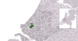
 Location in South Holland | |
| Coordinates: 51°59′N 4°19′E / 51.983°N 4.317°E | |
| Country | Netherlands |
| Province | South Holland |
| Established | 1 January 2004[1] |
| Government | |
| • Body | Municipal council |
| • Mayor | Arnoud Rodenburg (CDA) |
| Area | |
• Total | 49.38 km2 (19.07 sq mi) |
| • Land | 47.19 km2 (18.22 sq mi) |
| • Water | 2.19 km2 (0.85 sq mi) |
| Elevation | −2 m (−7 ft) |
| Population (January 2021)[5] | |
• Total | 19,414 |
| • Density | 411/km2 (1,060/sq mi) |
| Time zone | UTC+1 (CET) |
| • Summer (DST) | UTC+2 (CEST) |
| Postcode | 2635–2636, 3155 |
| Area code | 010, 015 |
| Website | www |
Midden-Delfland (Dutch: [ˌmɪdə(n)ˈdɛl(ə)flɑnt] ) is a municipality (gemeente) in the Westland region in the province of South Holland in the Netherlands. It had a population of 19,414 in 2021, and covers an area of 49.38 km2 (19.07 sq mi) of which 2.19 km2 (0.85 sq mi) is water.
It was formed on 1 January 2004 through the merger of the former municipalities:
- Maasland (population: 6,844), covered an area of 24.42 km2 (9.43 sq mi) of which 0.6 km2 (0.23 sq mi) water.
- Schipluiden (population: 11,173), covered an area of 30.00 km2 (11.58 sq mi) of which 0.39 km2 (0.15 sq mi) water.
Population centres
[edit]The municipality comprises the population centres:
Topography
[edit]Dutch topographic map of the municipality of Midden-Delfland, June 2015
Geography
[edit]The green area that comprises the municipality of Midden-Delfland was named Midden-Delfland before 2004, and it referred to the green area surrounded by cities (such as The Hague and Rotterdam) and the horticulture area of Westland. The supporters of a continuous green area were lucky that the municipality of Midden-Delfland became a reality: the cities of Delft, Vlaardingen and Schiedam wanted to build new houses here, and the Westland gardeners also wanted to expand. Now, Midden-Delfland is designated as a recreation area for people from the surrounding cities.
Notable people
[edit]- Jan Vermeer van Utrecht (1630 in Schipluiden – ca. 1696) a Dutch Golden Age painter
- Marja van Bijsterveldt (born 1961) a Dutch politician, Mayor of Delft since 2016
- IJsbrand Chardon (born 1961) a Dutch equestrian and winner at the World Equestrian Games
- Ronald Vuijk (born 1965) a Dutch politician, alderman of Midden-Delfland 2011/2012
- Gerben Moerman (born 1976 in Schipluiden) a Dutch sociologist and academic
Gallery
[edit]-
Schipluiden - Gaag
-
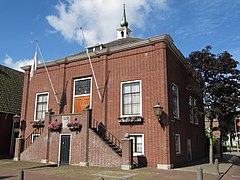
Maasland - Former city hall
-
Schipluiden
-
Hervormde Kerk Schipluiden
-
Hodenpijl, former church
-
De Zweth, bridge: Kandelaarsbrug
References
[edit]- ^ "Gemeentelijke indeling op 1 januari 2004" [Municipal divisions on 1 January 2004]. cbs.nl (in Dutch). CBS. Retrieved 13 August 2013.
- ^ "Samenstelling college" [Members of the board] (in Dutch). Gemeente Midden-Delfland. Archived from the original on 7 September 2013. Retrieved 14 August 2013.
- ^ "Kerncijfers wijken en buurten 2020" [Key figures for neighbourhoods 2020]. StatLine (in Dutch). CBS. 24 July 2020. Retrieved 19 September 2020.
- ^ "Postcodetool for 2636HX". Actueel Hoogtebestand Nederland (in Dutch). Het Waterschapshuis. Archived from the original on 21 September 2013. Retrieved 13 August 2013.
- ^ "Bevolkingsontwikkeling; regio per maand" [Population growth; regions per month]. CBS Statline (in Dutch). CBS. 1 January 2021. Retrieved 2 January 2022.


